

West Shore / Park planning
Emerald Bay State Park, Lake Tahoe
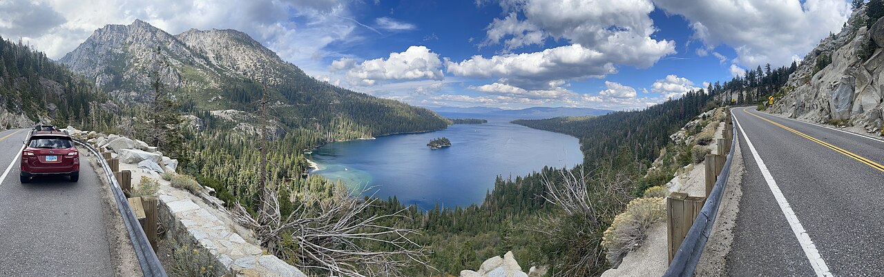
Plan your Emerald Bay visit around one decision: enjoy the view from above, hike down to Vikingsholm, or make a longer trail day of it. Each needs a different amount of time and energy.
Researched by the I Love Lake Tahoe Editorial Team. Primary sources rechecked October 25, 2026. This is a researched planning guide; it does not claim a field inspection.
Choose your visit
A scenic stop: choose the overlook if you want photos without committing to the hike down.
A history outing: make Vikingsholm your main activity and leave room for the uphill return.
A hiking day: choose a trail and turnaround point before adding a house tour or another stop.

Parking to Vikingsholm: the return is uphill
This diagram separates the upper viewpoint from the lake-level visit. It is a route sequence, not a geographic map or measured elevation profile.
Park here · overlook option stays above the bay
About 1 mile downhill
Commit to the return before descending.
About 1 mile uphill
Return to the same parking lot.
House exterior, beach and connections to other trails
Why we do not print one exact climb: the official Vikingsholm page gives a 500-foot descent in one paragraph and a 400-foot round-trip gain in another. We cannot resolve that discrepancy from the published text. Plan for a substantial uphill return; neither figure is a measured accessibility assessment. State Parks warns that ordinary visitors cannot count on a ride out.
Open the official park map (PDF, final page) for geographic orientation. The brochure was revised in 2017, so use it for the layout, alongside current operating notices. Open the Vikingsholm parking destination for your drive; a road route to the lot does not provide vehicle access to the house.
Emerald Bay parking and fees
Emerald Bay is on Highway 89 on Lake Tahoe’s California shore. For the overlook and Vikingsholm hike, use the Vikingsholm parking lot. The park lists $10 daily parking or $3 for one hour, with cash or card payment. Day-use hours are sunrise to sunset. The Vikingsholm lot has an 18-foot maximum vehicle length and does not allow trailers. Parking is limited, and Highway 89 roadway parking is prohibited. See official park notices and fees.
Choose the day rate for a lake-level visit instead of trying to fit the descent, sightseeing and climb into a one-hour parking stop. An early arrival can give your day more flexibility, but it does not guarantee a space. If the lot is full, use your backup plan rather than circling indefinitely.
Shuttle status, checked October 25: Tahoe Transportation District now asks riders to check back for summer 2027 dates. The old timetable remains below that notice; it is not proof of autumn service. Do not rely on it for a ride home.
Vehicle-limit source check: use the current page’s section titled “Vikingsholm Parking Lot”: 18 feet maximum, no trailers. The 2017 brochure discusses different lengths for campground sites. A campsite allowance is not permission to enter this day-use lot.
Vikingsholm hike and tours
The Vikingsholm Trail is about 2 miles round trip, with a steep descent to the house and an uphill return to the parking lot. Treat it as a hike, even if the house tour is your main reason for visiting.
The 2026 house-tour season has ended. The Sierra State Parks Foundation published May 23–September 30 dates. Its 2026 schedule was a 30-minute tour every half hour from 10:30 a.m. to 4 p.m., except 12:30. The following are the published 2026 prices for planning context; confirm new dates and prices before a future trip. Tickets were sold first come, first served at the visitor center beyond the house.
- Adults: $18.
- Ages 7 to 17, students with valid college ID, active-duty military and seniors: $15.
- Children 6 and younger: free.
2026 tour-season budget example: two adult admissions ($18 each) plus $10 day parking total $46. Two adults and two children aged 7–17 would total $76; with two children six or younger, $46. These examples exclude food and transport and do not mean tours are operating now. Allow for the descent and ticket queue before any tour time.

Which Emerald Bay trail should you choose?
Vikingsholm for the house and shoreline
Choose this route if you want to spend time at lake level. Pack only what you are comfortable carrying back uphill. With children, decide your turnaround based on the return climb, not just how easy the descent feels.
Eagle Falls and Eagle Lake for a hiking outing
Use our Lake Tahoe waterfall guide to distinguish Upper and Lower Eagle Falls, then check the route details in our Eagle Falls to Eagle Lake guide. Pick the exact trail before setting your day’s schedule; a waterfall stop and a lake hike are different commitments.
Rubicon Trail for a longer shoreline walk
Compare the Rubicon Trail route options before choosing your start and turnaround. Include the walk back to your own vehicle in the plan, especially if you also want a Vikingsholm tour.
Our Rubicon Trail hiking guide compares the starting points at D.L. Bliss, Vikingsholm and Eagle Point, explains the differing park distance estimates and helps you account for access walks and the return to your vehicle.
Seeing Emerald Bay from the water
Rentals are closed for the 2026 season. Kayak Tahoe’s Emerald Bay location lists a weather-dependent May 29, 2027 reopening. Its beach counter is north of the Vikingsholm pier, reached by the same downhill trail. It offers single and double kayaks, with no paddleboards at this location. Rentals are first come, first served; bring photo ID and cash as a backup. Confirm operations before planning a future rental day.
For future budgeting, the operator’s published rates are $40/$50 for a single kayak for one/two hours and $55/$85 for a double. Rentals include a life vest, paddle and basic instruction. Participants must be at least 4 and weigh over 30 pounds; anyone taking their own vessel to Fannette Island must be older than 15. Read the full supervision rules with the operator before choosing equipment for children. These are published planning prices, not a guaranteed 2027 quote.
State Parks prohibits swimming to Fannette Island and closes the island in April–May for wildlife. Avoid paddling on wind-advisory days. Boat-camp buoys are reserved for registered campers; use designated anchoring areas to protect underwater artifacts.
A sightseeing cruise is another choice if paddling or the return climb does not suit your day. Check the departure dock, boarding access and whether the itinerary actually lands: seeing Vikingsholm from a boat does not necessarily include visiting it. Compare departures in our Lake Tahoe boat-tour guide.
Eagle Point or Boat In camping?
Both campgrounds are closed for the 2026 season. For a future open season, the park’s camping information distinguishes road-access Eagle Point from Boat In on the north shore of the bay. Boat In has no vehicle access or designated boat launch. A reservation does not permit overnight parking in the Vikingsholm lot.
Reserve through ReserveCalifornia up to six months before arrival; check the exact site’s vehicle and party limits. Store food, toiletries and coolers in the provided bear locker. Eagle Point’s listed locker interior is 36 inches deep, 43 wide and 22 high. Confirm future dates and site fees before booking; old season dates are not availability.
Choose Eagle Point when your plan depends on a car at the campground. Choose Boat In only after settling the arrival route, equipment transport, overnight vehicle location and return plan. A day rental at Vikingsholm does not settle those overnight arrangements. Our Tahoe camping guide compares other bases.
Build a visit you can comfortably finish
Choose one main objective. These are our planning suggestions, not measured journey times. Conditions, your group’s pace and parking decide what is practical on the day.
Plan A · Overlook and a flexible second stop
Choose this if the view is your main reason to visit, time is short, or the return climb does not suit your group. Use a legal parking space, enjoy the upper viewpoint, then leave without adding the descent. If there is no space, continue to a planned alternative rather than improvise on the highway. Our Tahoe City town guide offers a different waterfront day when your route already takes you north.
Plan B · Lake-level outing, with or without a tour
Before walking down, confirm everyone can return uphill and carry their own essentials. Set a return deadline based on daylight and your group’s pace. At the bottom, choose the house exterior and shoreline as the core outing. Add an interior tour only during a confirmed operating season; a closed house need not cancel a suitable outdoor visit. Avoid stacking another major hike onto a tired group’s return.
Plan C · A dedicated hiking day
Pick the exact trail and starting lot first. For a Rubicon out-and-back from Vikingsholm, add both access legs to your shoreline mileage. For Eagle Lake, follow that trail’s separate access and permit guidance. Do not assume the names “Eagle Falls” and “Vikingsholm” describe the same route.
Do the return-distance calculation first
From the Vikingsholm lot, the base walk is approximately 1 mile down + 1 mile back up. If you add a shoreline out-and-back of x miles each way, your planned walking distance is approximately 2 + 2x miles, before small detours. A half-mile extension each way makes roughly 3 miles; one mile each way makes roughly 4. These are arithmetic examples, not trail measurements or recommended turnaround locations.
Three decisions to make before descending
These are our worked planning examples using the published inputs above. They are not bookings or measured journey times.
Two adults: one double kayak or two singles?
For one hour, the listed equipment cost is $55 for one double versus $80 for two singles: a $25 difference. For two hours it is $85 versus $100: a $15 difference. Adding $10 day parking gives $65/$90 or $95/$110 respectively, before any other fees or purchases. Decide whether you want a shared boat or independent paddling; the cheapest option may not fit your group. Both choices still include the descent and uphill return.
A four-hour stop: how much time is really at the shore?
Start with a hypothetical 240-minute visit. If your group allows 40 minutes down, 70 up, 20 for parking and preparation, and 30 as a buffer, only 80 minutes remain at lake level. A one-hour rental would leave just 20 minutes for its queue, fitting and everything else. Those walking allowances are assumptions to replace with your own realistic pace. If the remaining margin is too small, keep the visit to the house exterior and beach or skip the descent.
Camping gear: will your cooler fit?
Compare the cooler’s outside dimensions, including handles, with the locker dimensions above. A cooler 24 inches tall cannot stand upright in a 22-inch-high locker even if its length fits. Decide how you will store it and the rest of your food before packing the car; do not assume an insulated cooler can stay in the vehicle.
Before leaving the car
- Check the current road, weather and trail notices; save the map where you can open it without reception.
- Carry water, food, layers and footwear suitable for the actual surface; keep hands free for the walk.
- Choose the return deadline before descending. If someone is unsure about the climb, keep the outing above the bay.
- Read the parking sign, pay for the time you need and keep the return to the correct lot in your plan.
Visiting in fall and winter
Current autumn status: the park’s update checked October 25, 2026 says Eagle Point and Boat In campgrounds have closed for the season. Do not treat older opening dates elsewhere on the page as a booking offer. Compare alternatives in our camping guide.
In winter, snow and ice can make the Vikingsholm descent hazardous. State Parks lists no services or drinking water from October through May, and phone reception can be unreliable. Check the park’s winter advice and our Lake Tahoe conditions guide before leaving.
For an autumn itinerary, keep Emerald Bay as a flexible outdoor stop and pair it with our October planning guide. If conditions make the trail unsuitable, choose another activity before you drive there.
Dogs and accessibility
Pet dogs may visit the Vikingsholm parking-lot overlook, but are prohibited on the trails down, beach, Vikingsholm grounds and Rubicon Trail. Check the park’s dog rules or choose a dog-friendly Tahoe beach.
The State Parks accessibility page identifies the main Vikingsholm descent as inaccessible. It separately describes two short accessible segments at the bottom: 0.03 mile near the house and 0.03 mile toward the visitor center. Those segments do not solve the descent. The Foundation’s assistance program lists June–September and requires advance coordination via [email protected]. Confirm eligibility and availability directly; do not arrive expecting an on-demand ride.
A different overlook route: the accessibility page also documents an approximately 0.18-mile Overlook Trail inside Eagle Point Campground, starting near campsite 28, with accessible parking near campsite 31. It lists average running slope 5% and maximum 10%. This is not the Vikingsholm parking-lot overlook or a substitute route down to the mansion. Because the campground is seasonally closed, confirm road access before relying on that parking; a walk-in approach changes the outing.
What to notice at the house and bay
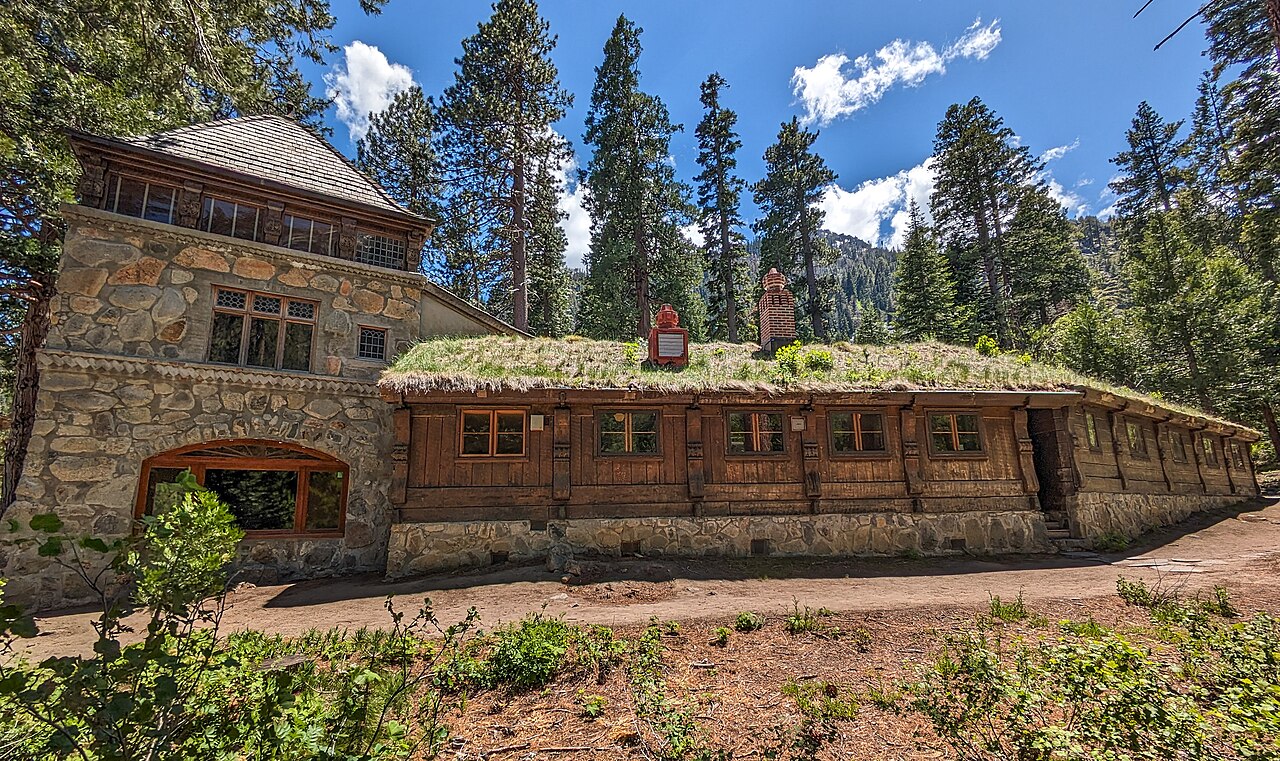
The State Parks history of Vikingsholm explains the Scandinavian design, hand-worked timber and living sod roofs. If architecture is your interest, that makes the house the destination rather than simply a stop on a hike. The park brochure also describes Fannette Island’s remaining stone teahouse shell and the bay’s glacial landscape. Viewing the island from shore and visiting it by water are different outings; compare an operator’s actual itinerary before booking.
Sources and corrections
We checked the linked State Parks park, Vikingsholm and accessibility pages, the Sierra State Parks Foundation tour information, Tahoe Transportation District’s shuttle notice, and Kayak Tahoe’s location, rates and restrictions on October 25, 2026. The dated brochure supplies geographic and historical context. Our diagram, outing choices, cost comparisons, packing example and time/distance budgets synthesize those sources; they are not survey data or firsthand trail reports. Report an error through our contact page.
Plan the rest of your Tahoe day
Want a beach-focused outing? Compare Lake Tahoe beaches. Prefer to see the bay from the water? Our boat tour guide helps you compare departure points and trip types.