

Fallen Leaf Lake Tahoe hiking trails start at two very different ends of the lake. Choose the campground at the north end for a shorter forest-and-shore outing. Choose Glen Alpine Trailhead near Lily Lake at the south end for Grass Lake or longer Desolation Wilderness hikes. The newer Lily Lake Trail climbs toward Angora Ridge; it is a rocky hillside connector, not an easy stroll around Lily Lake.
Access and sources checked October 25, 2026. This guide distinguishes published route distances from shorter, self-selected turnarounds. The maps locate arrivals, while linked trail and campground maps supply more detail. It does not claim a field-measured GPS track.
Choose the outing before choosing the parking pin
North end: campground and shore
For: families, lake views and a flexible turnaround.
The Forest Service describes the Moraine Trail as a 1.1-mile loop from the campground. A separate tourism listing describes a longer 3.5-mile shoreline out-and-back. Neither is a full-lake circuit.
Watch for: seasonal campground access, unclear junctions, brush and the distinction between a dog-friendly trail and a restricted beach.
South end: Glen Alpine to Grass Lake
For: a more substantial mountain walk.
The Forest Service destination table gives 2.3 miles each way, or 4.6 miles out and back. Another agency description says three miles each way; allow for the discrepancy when planning.
Watch for: rough footing, climbing, seasonal road access and the wilderness permit.
Above the lake: Lily Lake Trail
For: confident walkers seeking elevated views.
2.1 miles one way between the Glen Alpine/Lily Lake area and the Angora trail system; approximately 4.2 miles returning the same way. The project partner reports an 800-foot elevation change.
Watch for: exposed rock, cliff-edge terrain and other trail users. This is a different choice from the campground shore.
Lower Glen Alpine Falls
For: a brief waterfall stop on the south-end approach when lawful parking is available.
The lower falls are beside the road before the Glen Alpine trailhead. Their short approach does not make the rocks safe to climb or guarantee a parking space.
Watch for: seasonal flow, slippery rock and the narrow road. Keep this separate from a Grass Lake hike.
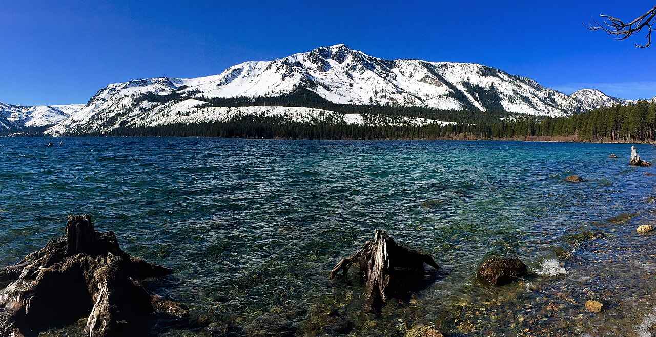

The campground shoreline approach
From the Highway 50/89 junction in South Lake Tahoe, follow Highway 89 north roughly three miles and turn onto Fallen Leaf Road. The campground entrance is about half a mile along, on the right. Use Fallen Leaf Campground, 2165 Fallen Leaf Road, as the arrival destination, then confirm the allowed day-use parking area at the entrance. Campsite parking is not automatically public trail parking. Campground directions and visitor information.
The 2024 concessionaire guest map, page 1 labels Moraine Trail at the campground’s southwest edge, near the loop around sites 74–76. Use those numbers to orient yourself on the map, not as permission to park in an occupied campsite. Follow the signed public path and the current entrance instructions.
A named short route: the Forest Service Moraine Trail page, updated May 29, 2026, identifies trail 17E74 as a 1.1-mile loop from the campground overflow parking, reaching Fallen Leaf Lake and Taylor Creek. It lists 35–72 feet of gain and a natural-ground surface. Its driving directions place parking on the right just before campsite 75. Follow current signs and the operator’s instructions; the numbered campsite itself is not a public parking space.
The tourism bureau’s longer shoreline outing is a separate 3.5-mile out-and-back with roughly 150 feet of gain and potentially overgrown sections. Do not add its distance to the Moraine loop or use the two names interchangeably. For the short loop, follow the signed Moraine route back to its starting lot; if you instead choose an early shoreline turnaround, retrace your approach.
For a short visit: walk to the first suitable public lake-view area and return along the route you used. Photograph the junction sign on the way out and mark the parking location in your offline map. Stop earlier if brush, mud, snow or an unclear junction makes the return uncertain. The extra walk from a closed gate or a different parking area is not included in a published trail distance.
For the longer shoreline outing: save a detailed route before leaving service and identify its turnaround. The tourism listing does not name that endpoint, so this guide does not invent a landmark to make its 3.5-mile figure appear more precise. Private docks, driveways and visible shoreline are not invitations to continue through private property.
Glen Alpine Trailhead and the Grass Lake option
Continue along the narrow Fallen Leaf Road around the south end of the lake. The Forest Service directs drivers to turn left before the bridge, then continue toward Lily Lake. Glen Alpine Trailhead is across from Lily Lake; its agency coordinates are 38.87711338, −120.0802252. This is not the campground entrance. Leave time for pedestrians, cyclists and oncoming vehicles rather than using an optimistic drive-time estimate. Official trailhead directions.
From the trailhead, use the signed Glen Alpine route and the signed Grass Lake branch shown on your offline map. Return on the same route. Do not follow a different lake name simply because it appears on the same trailhead board; the basin has numerous longer destinations.
The Forest Service’s destination table, updated July 21, 2026, lists Grass Lake at 2.3 miles one way, rated easy/moderate. Its separate trailhead narrative says three miles. Treat 4.6 miles as the table-based round trip and allow capacity for a longer outing while you confirm the exact route. “Easy/moderate” describes that route relative to the wilderness network; it does not mean flat, paved or stroller-ready. A verified cumulative elevation gain is not supplied by these pages.
How much longer are the other Glen Alpine hikes?
The same agency table lists Susie Lake at 3.8 miles one way, Gilmore Lake at 3.9, Heather Lake at 4.9 and Lake Aloha at 5.8. Returning along the same route gives approximately 7.6, 7.8, 9.8 and 11.6 miles, respectively, before any extra exploration. Lake Aloha is rated difficult. These are separate objectives requiring their own route, elevation, time and permit planning.
Mount Tallac from Glen Alpine is also a separate mountain outing. Do not combine a casual shoreline visit with an unplanned summit attempt; compare our Mount Tallac guide.
Lower falls versus the hiking trailhead
The tourism bureau distinguishes the roadside lower Glen Alpine Falls from the upper falls and hikes accessed farther along at the trailhead. The lower falls can be a short stop, but legal parking and a clear road still come first. Do not block the fire station, gates or passing space. Water volume varies with snowmelt and season; avoid scrambling on wet rock for a closer photograph. Glen Alpine access and waterfall description.
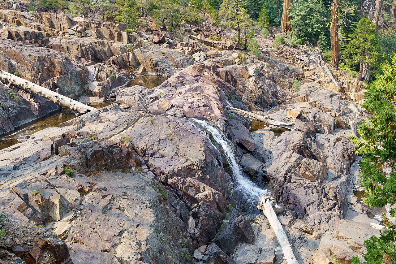

Lily Lake Trail is a hillside connector
The Tahoe Fund describes a 2.1-mile multi-use trail with an 800-foot elevation change, including slickrock, boulder traverses and an overlook beside a 75-foot cliff. It connects the Glen Alpine/Lily Lake area with the Angora Ridge trail system. The tourism bureau identifies the other end at the Angora Lakes parking area. Choose your starting end deliberately: a one-way connector leaves you at a different arrival point. Trail project details and endpoint description.
Walking its full length and returning the same way is approximately 4.2 miles. The reported elevation change is not a surveyed cumulative-gain total, and parking-to-trail connections add distance. Share the route with other users, keep clear of exposed edges and do not treat a wet or icy rock traverse as an ordinary shore walk. For a family wanting a gentle lake visit, the campground approach is the more suitable starting comparison.
Parking, facilities and seasonal access
Fallen Leaf Campground
The campground page lists a day-use parking fee without an amount, while the Moraine Trail page says trail day use has no fee. Do not treat that as a promise of free campground parking. Confirm the charge and designated spaces with Tahoe Recreation at 530-541-1537; overnight campsite prices and old extra-vehicle charges are different items.
Restrooms operate with the campground; its winter notice says no restrooms or trash service. The agency page says potable water is unavailable, while Recreation.gov describes campground spigots. Bring your own drinking water and confirm seasonal service. Official campground page.
Glen Alpine Trailhead
The Forest Service lists no site fee, seasonal parking, vault toilets and no potable water. Winter restroom and trash services are unavailable. Camping or sleeping overnight at the trailhead is prohibited.
An “open 24 hours” listing does not guarantee that the approach road or parking is usable in snow. Check the Forest Service conditions page and the specific trailhead notice before driving.
The two parking areas are not interchangeable overflow lots. If the chosen arrival is unavailable, select another outing with a legal start instead of leaving the vehicle on vegetation, blocking a gate or squeezing into a narrow passing area. An off-season walk from a lawful parking location can be longer than the summer route.
Dogs, wilderness permits and access needs
Can I bring a dog to Fallen Leaf Lake?
The tourism trail description allows leashed dogs, and the Forest Service asks hikers to leash pets and remove waste. However, Fallen Leaf’s campground booking rules specifically prohibit pets on the beach. Treat trail access and beach access separately, obey signs and confirm the intended shoreline stop with the operator. Do not describe the entire lake edge as a dog beach.
When do I need a Desolation Wilderness permit?
Permits are required year-round for day and overnight entry into Desolation Wilderness. Day hikers can generally self-issue at the Glen Alpine kiosk; arrange the appropriate permit before proceeding if it is unavailable. Overnight visits require advance planning, applicable fees and a hard-sided bear canister. No wood or charcoal campfires are allowed in the wilderness. These requirements apply to wilderness entry, not simply to visiting the campground shore. Official wilderness rules.
Strollers and mobility access: accessible campground restrooms do not establish an accessible trail to the lake. The shoreline approach can include uneven ground and brush, and Lily Lake Trail has substantial rock features. No continuous wheelchair-accessible route is verified here. Ask the operator about the exact path, surface, grade, restroom and parking space you need before making it the day’s main outing.
Two arrival maps
These pins use the Forest Service’s published coordinates. They identify the campground area and Glen Alpine trailhead, not a guaranteed empty space or a complete hiking route. Save a detailed trail map before leaving mobile service.
A realistic time and turnaround plan
Compare the time commitment
Planning example: 1.5 mph while moving, plus the stated stop. All bars share a five-hour scale. Teal shows walking; gold shows the stop. The two Grass Lake rows show the consequence of the conflicting source distances, not two verified routes.
Moraine loop
1.1 miles + 20-minute stop = 1 hr 04 min
Published short loop; campground approach may add distance.
Longer shoreline outing
3.5 miles + 30-minute stop = 2 hr 50 min
Tourism listing; turnaround must be identified before starting.
Grass Lake: destination-table distance
4.6 miles + 30-minute stop = 3 hr 34 min
2.3 miles each way in the agency table.
Grass Lake: trailhead-narrative distance
6 miles + 30-minute stop = 4 hr 30 min
Three miles each way in the other agency description; same destination, unresolved distance difference.
With a three-hour window: the longer shoreline example leaves only ten minutes for parking, extra approaches and delays. That is a narrow margin. Compare the shorter Moraine loop instead, confirm access and set a turnaround that suits the slowest person. Neither Grass Lake calculation fits that window with the planned stop.
Limits: these are calculations, not measured hiking times or an elevation profile. Climbing, rough footing, snow, navigation, closed-gate approaches and other delays can add time. Allow a margin before sunset and turn back earlier when conditions or the group require it. The source discrepancy remains unresolved; choose a saved route and confirm its length rather than assuming the shorter number.
Short-loop planning calculation: 1.1 miles at 1.5–2 mph is about 33–44 minutes moving. Add a 20-minute lakeside stop for roughly 53–64 minutes, before parking or any walk from a closed gate. This is arithmetic from the published distance, not a measured family hiking time. Snow, mud and frequent stops can make it longer.
Original planning calculation: at a walking pace of 1.5–2 miles per hour, the published 3.5-mile shoreline outing requires about 1 hour 45 minutes to 2 hours 20 minutes of walking. Adding a 30-minute shore break gives roughly 2 hours 15 minutes to 2 hours 50 minutes, before parking delays. That is more generous than the tourism listing’s 1–1.5-hour estimate and better suited to a leisurely visit.
For Grass Lake, 4.6 miles at the same assumed pace takes approximately 2 hours 20 minutes to 3 hours 5 minutes without breaks. If your chosen route is six miles, as the other agency description implies, that becomes 3–4 hours. Rough terrain, climbing, stops and conditions can make either estimate longer; these calculations are planning examples, not promised completion times.
- Before driving: choose the route, confirm the parking approach and services, save maps and check road and weather reports.
- At the start: note the actual parking location, read the trail board and set a turnaround time that leaves daylight for the return.
- At the first uncertainty: stop and check the map. Turn back if the route, water crossing, snow or footing is beyond the group’s preparation.
- On return: use the same route and pack out food scraps, litter and pet waste. Keep food secure and give wildlife space.
Spring snow and wet ground can change a low-elevation outing; compare our April and May hiking guide. For alternatives, see Eagle Lake, Mount Tallac and the Lake Tahoe hiking overview. The tourism bureau’s Fallen Leaf overview also distinguishes the gentler campground approach from the more strenuous south-end options.